Snow distribution and strathigraphy in Tarfala Valley
Mats Granskog
Dept. of Geophysics, University of Helsinki
P.O.Box 4, FIN-00014 University of Helsinki, Finland
Abstract:
The snow distribution along a one kilometer long line was examined along the valley, and along a few transects. In addition few other profiles were made in vicinity of the station. Snow pit strathigraphy was examined in two snowpits in the valley. The spatial variation of the snow depth is significant, depending mainly on the wind conditions and the local topography of the surface (which couldn't be seen under the snow cover). The snow depth varied from 0 to 3 meters. The density in the snow cover didn't vary much, the density varied between 300-500 g/l, but several different layers could be distinguished.Introduction
The spatial distribution of snow is typically heterogenous. The spatial variability may be caused primarily by surface features which significantly affect the velocity of wind near the surface, and thus affect the capability of the wind to entrain, transport, and deposit snow. Such features include large-scale topography, affecting convergence and divergence of the wind flow over many tens of meters, and local topographic discontinuities which may cause acceleration or reduction of the wind velocity and possibly flow separation. In Tarfala valley the local scale features, such as rocks, moraines etc., is the main cause for the heterogenous (re)distribution of snow.
During the Glaciology Field Course in Tarfala Research Station on April 20th to 25th the snow distribution and strathigraphy in the Tarfala Valley was examined. At a first glance the snow cover in the valley was thick, about 2 meters in the vicinity of the station. But a closer examination shows great variability in the snow cover thickness. During the field study week approximately 15-20 cm of new snow precipitated.
Methods
The snow depth profiles were measured by skiing along a line and measuring the depth using a metal stick with a scale with (approximately) 10 or 25 meters intervals. The snow pits were measured for their density and temperature with depth. Density measurements were made by using a snow sampler of 1 liter volume. After the snow sample was taken the sample was put in an plastic bag and weighed with an spring balance, this was done for every 5 cm intervals. The temperature was measured with an digital thermometer every 5 cm. The location of the snow profiles can be seen in Appendix A.
Results and discussion
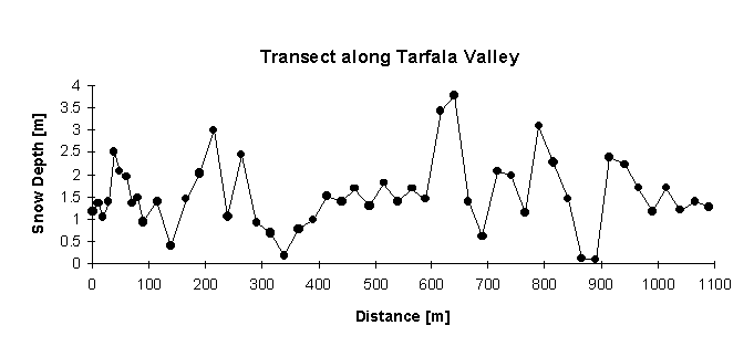
The snow depth profiles in the valley shows high spatial variability in snow depth. The non-uniform snow cover is mainly due to topographical and wind effects. Windblown snow accumulates on lee sides of bumps and rocks, and is blown away from more windy locations. In Figure 1. the snow depth profile along the valley can be seen (Line 1. Appendix A), on average the snow depth is is 1.55 meters. The depth varies between 0.08 and 3.78 meters. Two snow profiles were made across the valley (Line 2. about 240 m and Line 3. about 690 m from the station); Line 2. (Fig 2.) at stake 13. and Line 3. (Fig 3.) at stake 22. on the stake line along the valley. The average snow depth on these profiles is 1.62 m and 1.76 m for Line 2. respective Line 3. , not substantially different compared to Line 1. On average the snow depth is quite uniform on both sides of the main stake line, even if the part on the east side of the profile along the valley has an slope of 10 to 20 meters per 100 m. The slope seems not to effect the snow depth, at least not with an gentle slope(< 11° ). In the western end of Line 2. the snow depth a bit further away from the moraine (old frontal moraine of Isfallsglaciä ren) reaches its maximum and decreases close to the moraine (this could be due to measurements on top of the moraine), on Line 3. this feature can't be seen. The maxima is caused by snow accumulated in front of the moraine due to decreased wind speed.
Fig 1. Line 1., ie. snow depth profile along the valley, starting at the station.
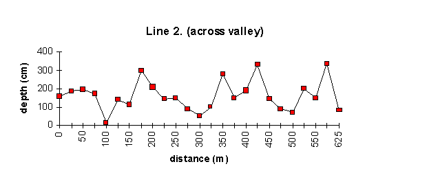
Fig 2. Line 2., ie. snow depth profile across valley, about 240m from the station
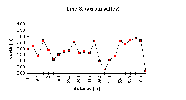
Fig 3. Line 3. ie. snow depth profile across the valley, about 690 m from station
The snow profiles made southeast from the station (Lines 4 to 7, see Appendix A for location) were measured with approximately 21 meter intervals, except Line 7. with 8 meters intervals. On average the snow depth is lower in these profiles, 1.29 m, 0.81 m, 1.10 m and 1.56 m for Lines 4. 5. 6. and 7. respectively. The two profiles made across the valley (ie. Lines 5 and 7) shows a distinct thickening of the snow cover towards lower elevations (Figures 5 and 7), but on average the snow depth on Line 6. is higher than om Line 4. This could be caused by the topography acting on the wind flow down on the valley bottom. The wind flow might be accelerated and the amount of wind blown snow is increased, because the amount of wind blown snow is proportional to the wind speed and hardness of the snow cover. The two distinct minima on Line 4. are caused by high wind speeds, topography (or both) or human activity. The first minima (at 140-200 m) is probably caused by human activity and the second one (at 450-550 m) by wind acceleration due to the (old) frontal moraine of Storglaciären. The minima at about 450-500 m on Line 5 can be caused by higher wind speeds in front of the moraine or direct measurements of snow cover on top of the moraine.
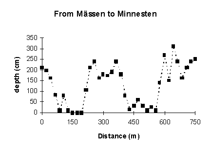
Fig 4. Snow depth profile along Line 4.
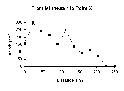
Fig 5. Snow depth profile along Line 5.
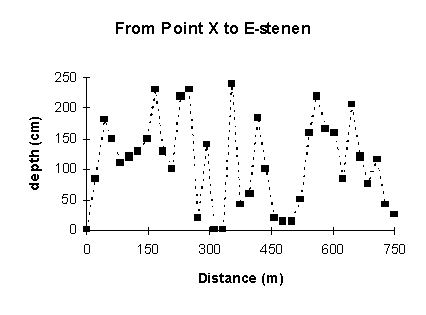
Fig 6. Snow depth profile along Line 6.
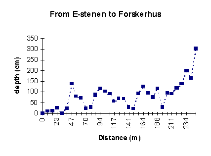
Fig 7. Snow depth profile along Line 7.
The two snow pits made in Tarfala valley (the exact location is unknown) show great variability of snow density versus depth. The mean density in the pits are 369 g/l and 394 g/l for Pit 1. resp. Pit 2. (Figs 8 and 9). If we don’t take into account the low density snow layer on the topmost part of Pit 1., the average density increases to 392 g/l, almost the same as in Pit 2. were this low density layer doesn’t exist (or isn’t taken into account in the measurements?). Wind packing of snow is probably the most important factor, in addition to melting snow, for the density stratification of the snow cover.
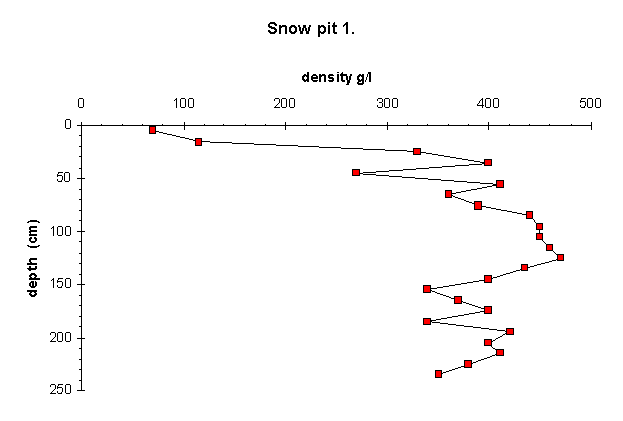
Fig 8. Snow pit 1. from Tarfala valley
Fig 9. Snow pit 2. from Tarfala valley.