A report on firn aquifer investigation at Storglaciä ren, North Sweden
M.Vasic. MA, MSc Department of Geography
University of Manchester, Manchester, M13 9PL. England
The following report details work done on Storglaciä ren, Swedish Lapland between 20/04/97 to 25/04/97 as part of the European Union funded glaciological training course at Tarfala Research Station. Members of the course took part in several ongoing projects supervised by staff from Tarfala Research station.
Introduction
Firn layers on glaciers are temporal reservoirs holding water to be released during the melt season by percolation. Water stored in the firn aquifer and released slowly has an undetermined effect on the hydrological conditions of a glacier. The processes involved are poorly understood, and the contribution to discharge measured at the terminus is difficult to determine. As part of a Masters program (1994) and now as part of PhD research Thomas Schneider has been investigating the characteristics of storage in a firn layer and calculating the flow velocity through it. During the period of the training course 3 boreholes were drilled through the snow and firn of the accumulation layer to the snow-ice transition as part Schneider’s continuing research into the dynamics of firn aquifers.
Field Investigation and study site
Storglaciä ren is a temperate glacier located in northern Sweden draining the east side of Kebnekaise, Sweden’s highest point. Storglaciä ren is 3 km in length ranging from 1720 m a.s.l to 1135 m a.s.l, with an area of approximately 3.1 km2 that remains snow covered from September to mid-July (Schneider 1994).
Limited time and poor weather conditions during the 5 day study period allowed for only one day of drilling on 24 April. No boreholes were instrumented at the time of drilling but water level was sounded manually using an electrical plumb. Holes were drilled using a manual propane driven thermal drill. Drilling velocities were recorded at 1m depths. Changes in drilling velocity are used to infer changes in snow and firn densities, and the existence of any impermeable ice lenses can also be determined. The presence of an extensive and adequately thick ice layer would provide the maximum depth of a firn aquifer.
Results
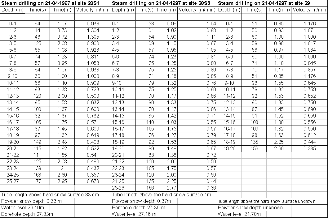
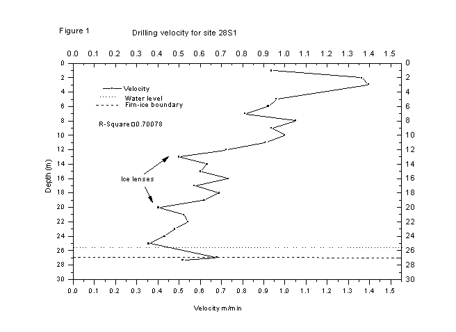
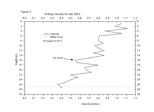
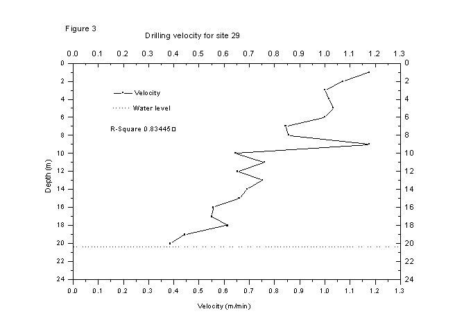
Depths of the boreholes were similar at both 28S1 and 28S3 reaching 28 m (Table 1). The borehole at site 29 was considerably shallower at 20m (Table 1). Plotted drilling velocities exhibit a strong negative correlation with depth (Figures 1 to 3). There is, however, some variation in the velocity-depth relationship. Near the surface at 28S1 a rapid increase in drilling velocities is recorded. The most obvious increase in drilling velocity occurs at site 28S1, rising from 0.9 m/min to over 1.4 m/min at a depth of 2m (Figure 1). A similar increase in velocity occurs at site 29 but at a greater depth of 9 m. Notable decreases of drilling velocity occur at 10m,14 m and 16m depth at sites 29, 28S1 and 28S3 respectively, possibly identifying ice lenses, increasing drilling time by up to 15% at site 28S3 (Figure 2). This denser layer has its maximum depth, between 1 - 2m, at 28S3 (Figure 2). At site 28S1 the dense layer disappears relatively quickly but is followed by another dense layer, also short lived, before finally giving way to ice at 27 m, noted by sharp a change in velocity (Figure 1). The ice layer is thought to be at 27.16m at 28S3. Drilling records were inconclusive with respect to the firn-ice transitional layer at site 29.
Water levels measured by electrical plumb line are very close to the firn ice transition appearing to be below what might be considered as the ice-firn interface in most cases. The clearest demarcation of the firn-ice boundary was recorded at 28S1 (Figure 1).
Table 1. Drilling statistics for all the boreholes
Discussion
If velocity is accepted as analogous with snow and firn density then it can be seen that as depth increases so does density. The positive depth-density relationship was true in all cases. The density record revealed a consistency between density pattern at all the sites with some local variation. After initial oscillation between high and lower densities in the surface layers, there is a marked increase in drilling velocity and therefore an increase in density. This increase in density is consistent with the presence of an ice lens. It was not, however of a sufficient thickness to produce a pseudo firn ice boundary on which a reservoir may form. A high velocity layer identified near the surface at site 28S3 is probably due to the presence of depth hoar, large, unconsolidated snow crystals formed by sublimation (Paterson 1994). A similar high velocity layer observed at site 29, at a deeper depth and overlying a much denser layer, possibly marks a previous winter-spring, or late summer-autumn snow fall. The sharp change in density towards the end of the data record for site 28S1 has been interpreted as the true ice-firn boundary. A thin water layer was sounded above the transitional zone. The ice-firn boundary was not clearly identifiable at the other sites. The soundings may possibly have been identifying water as a product of the drilling process filling the newly drilled hole. The previous few days had seen cold weather with high snowfall that was typical of the late spring conditions of 1997. The colder weather would delay the percolation of surface melt. Consequently, the firn aquifer would be poorly developed.
Conclusion
This work, carried out over a short time period, is a small part of a much larger project and, therefore the conclusions that can be drawn from it are limited. It is evident, however, that the drilling technique was fast and highly efficient. The data collected is analysed easily, providing a quick assessment of the density profile of the snow pack. Interesting areas are quickly identified and can be investigated in greater detail. The conditions of the firn aquifer can be assessed and instrumented rapidly providing the data required to detail the contribution of the firn aquifer to the glacial hydrological system. From data gathered on 24 April, 1997 at the three sites the limiting effects of cold weather conditions can be discerned. The existence of only a thin water layer at the firn-ice boundary suggests that the contribution of the firn aquifer at the time of the study would be small. Instrumentation of the boreholes with pressure transducers at or near the time of study would provide an accurate record of the development of the firn aquifer.
References
Paterson, W. S. B. (1994 ): Physics of glaciers ( 3rd edn). Oxford: Peragamon Press.
Schneider, T. (1994): Water movement and storage in the firn of Storglaciä ren , Northern Sweden. Forskningsrapport 99.