GLACIOLOGY FIELD COURSE AT TARFALA RESEARCH STATION (EU PRACTICAL TRAINING PROGRAMME IN GLACIOLOGY) MARCH 25 - APRIL 1, 1998
Pirita Oksanen
REPORT
Snow depths, densities and temperatures from Storglaciären and Tarfala Valley
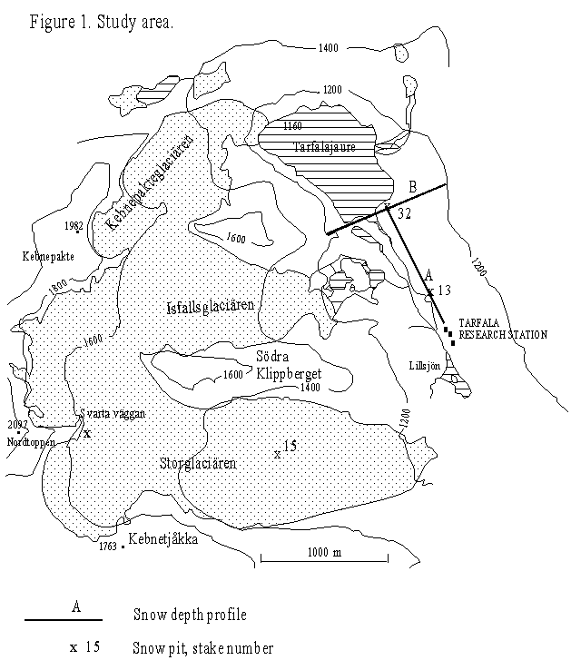
Study area (Fig. 1)
The Kebnekaise mountain massif is situated in northern Sweden (67o50’ - 60’N, 18o30’ - 40’ E). It belongs to the Scandinavian Caledonides. The mountain area is a mafic dyke complex, the Tarfala Valley consists mostly of amphibolites. The soil is mainly till. (Andréansson and Gee; 1989). The elevation of the area is over 1000 m a.s.l. Kebnekaise Sydtoppen is the highest point in Sweden (2117 m). The climate is arctic and maritime. At the Tarfala Research Station in the Tarfala Valley the mean annual temperature is -4 oC and precipitation about 950 mm. On Sydtoppen the mean annual temperature is about -11 oC. Snow cover remains about 290 days. The area is mountain tundra; the tree line is located at 700 m a.s.l. The glaciers lie mainly on the eastern slopes of the mountains, leeward to the prevailing winds. (Seppälä; 1989).
During the warm period after the Weichselian Glaciation the glaciers almost entirely disappeared from Scandinavia. Recent glaciers started to form about 4000 yr. BP, reaching their maximum extent about 400 yr. ago. Moraines of the previous glaciation phases are characteristic of the landscape. (Dolgushin and Osipova; 1989).
Storglaciären is the largest glacier in the Tarfala area, about 3 km2. It is a temperate valley glacier, 200-250 m deep. Its snow line is situated at about 1500 m a.s.l. The longitudinal profile is smooth. A rock bar beneath the 1450-1500 m ice surface causes crevasses on the downward glacier surface. (Björnsson; 1981). Storglaciären is the most detailed studied glacier in Sweden; regular mass balance measurements began in 1945 (Kovanen; 1989). Since that the balance has more often been negative than positive (Holmlund; 1987).
The Tarfala Valley is a typical U-shaped glacial valley. Glaciers have transported big boulders onto valley bottom. (Seppälä; 1989).
Significance
Climatic fluctuation causes variation in the accumulation and ablation of snow, and thus in advancing or retreating of glaciers. The change in mass of a glacier can be measured by mass balance studies. A balance year is the interval between two minima (summer layer) of the glacier surface. Maximum thickness is usually reached in late spring. The balance is measured by a grid of observation stakes and by digging representative amounts of pits or coring to the summer layer. At the end of a balance year the accumulation and ablation values are combined to determine the net balance of a glacier. Regular meteorological observations, e.g. precipitation and temperature measurements, are also carried out. Winter and summer balance are often counted separately. The correlation with meteorological data is higher for separated balances than the net balance. (Paterson; 1994). If a radar is used to survey the summer layer, pits or boreholes are needed in interpretation of the sounding results.
map from Seppälä; 1989, original Högfjällskartan Kebnekaise
Methods
Two snow depth profiles were made in the Tarfala Valley, one along the valley and one across it. The measured line A is a permanent study line of the Tarfala Station, marked by stakes. The transverse profile B goes across the valley cutting the last stake of the long profile. (Fig. 1). Probing was done manually with a measuring stick of length 250 cm. In places snow was deeper than this, but presumed not to be significantly deeper, which is also confirmed by radar sounding results (see the other reports). The first 500 m in the profile A, starting from the Tarfala Research Station were measured every 5 m and the last 550 m every 25 m. The profile B was probed every 20 m.
Two snow pits were dug in the Tarfala Valley, one at 235 m along the stake line beginning from the Tarfala Station and one at the northernmost stake No. 32; and two pits in Storglaciären, one in the accumulation zone, near Svarta väggan and one in the ablation zone, at the study stake No. 15. (Fig. 1). In the valley pits were dug to the ground and in the glacier to the summer surface. Density was measured every 5 cm using a box of known volume, which was gently pushed to the cleaned wall of the pit and weighted. Snow temperature was measured every 5-10 cm.
Table 1.
snow depth density accumulation as water
cm g/dm3 cm
Storglaciären
stake 15, whole 130 339 44
zone I 55 332
II 130 370
Svarta väggan 445 354 157
I 15 213
II 96 293
III 260 354
IV 445 395
Tarfaladalen
stake 13 134 337 45
I 10 230
II 50 310
III 95 393
IV 105 331
stake 32 235
profile A 114 38
profile B 138 46
mean 126 42
Results
Snow depth in the pit in the upper part of Storglaciären was 445 cm, in the lower part of the glacier 130 cm. In the valley snow depths varied from 18 to over 250 cm (Fig. 2). Generally, snow cover is deepest on gentle slopes. Winds, and specially in the valley, bottom topography effect snow depth. The mean density is 337-354 g/dm3. Zones can be distinguished in the density profiles: on the glacier, the density increases with depth. The mean density of the uppermost three zones of the deepest pit is the same as mean density of the shallower pits. In the valley, the density increases with depth until the bottommost zone, which has slightly lower density again. (Table 1).
Mean accumulation, expressed as water, in the valley and lower part of the glacier is 38-46 cm, and in the upper part of the glacier, 157 cm. Snow accumulation in the valley is calculated based on the mean density value of the pit at stake 13. Results from the glacier are based on the two study pits. Comparison to radar sounding profiles suggests that the pits represent the general snow depth values on the glacier well (see other reports).
The measurements were not done at the end of the winter season, but these preliminary results are within the average range of the yearly net accumulation of Storglaciären, which is 1.5-2 m in the upper parts and 0.5-1 m in the lower parts. The summer ablation in the upper parts is 1-3.5 m, in the lower parts 2-6 m (Kovanen; 1989).
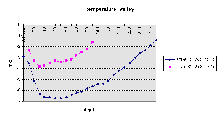
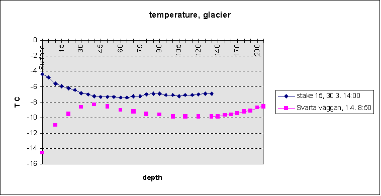
Snow temperature near the surface, to about 40 cm, reflects the temperature of the day of measurement. To a depth about one meter, snow temperature reflects weekly air temperatures. In three profiles, temperature variation between 40-100 cm is -7-9 oC. In the glacier profiles T becomes quite steady after about 30 cm. In the valley profiles, below 40 cm depth, T increases towards the earth, because of the warming effect of the earth and insulating effect of the snow. (Fig 3).
References
Andréansson Per-Gunnar and Gee David G (1989). Bedrock geology and morphology of the Tarfala Area, Kebnekaise Mts., Swedish Caledonides. Geografiska Annaler 71 A: 3-4, 235-239.
Björnsson Helgi (1981). Radio-echo sounding maps of Storglaciären, Isfallsglaciären and Rabots glaciär, northern Sweden. Geografiska Annaler 63 A: 3-4, 225-229.
Dolgushin L.D. and Osipova G.B. (1989) Ledniki. Moskva, Mysl’.
Holmlund Per (1987). Mass balance of Storglaciären during the 20th century. Geografiska Annaler 69 A: 3-4, 439-447.
Kovanen Anu (1989). Massabalanssi ja Kebnekaisen jäätiköiden sulaminen. Terra 101:3, 258-261.
Paterson W.S.B. (1994) The physics of glaciers. Pergamon/ Elsevier Science, Redwood Books, Trowbridge. 3. edition.
Seppälä Matti (1989). Jäätikkötutkimuskurssi Tarfalassa. Terra 101:3, 252-258.
Fig. 2. Snow depth profiles from Tarfala Valley. (see also Fig 1.)
Fig. 2. Snow depths in the Tarfala Valley
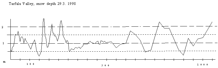
meters from Tarfala Station to north
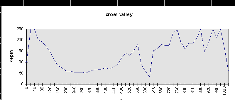
Fig 3. Snow temperatures.