A snow pit study in the surroundings of
Tarfala Research Station in Mars 1999
a student report from the course
Snow in Northern European Environment,
5th EU Glaciology Practical Training Course
at Tarfala Research Station, Sweden, 9-16 of March 1999
Supervised by Dr John Moore
Maria Johansson
Climate Impacts Research Centre (CIRC)
Björkplan 6A, S-981 42 Kiruna
E-mail mariaj@natgeo.su.se
Introduction and Background
This report is a final student report within the 5th EU practical course, the second part of the EU funded course "Snow in the Northern European Environment" arranged by Helsinki University and The University of Lapland, Finland. The field course upon which this report is based, was held at Tarfala Research Station between the 9th and 16th of Mars 1999.
During the course we conducted fieldwork along different themes. The themes were focused on GPS-measurements, drilling and taking ice cores from Storglaciären and the lake below, ground penetrating radar (GPR) measurements on Storglaciären and in the Tarfala valley and, description of snowpack properties on Storglaciären and in the valley.
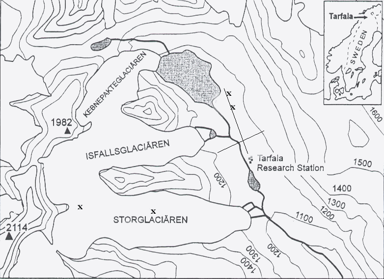
Figure 1.
Map of the Tarfala valley and Storglaciären (67° 55’N, 18° 36’E), in southern Sweden. X showing where the 2 snow pits discussed in this report are situated and the two lines show the two transects were the snow depth was measured. (Map modified after Grudd et al 1996)The Tarfala Research Station (Figure 1) is situated in northern part of the Swedish mountains (67° 55’N, 18° 36’E, 1130 m a.s.l.). The annual average air temperature in the Tarfala valley is -4° C, the average summer temperature is +5.5° C and the precipitation is approximately 1000 mm year-1 (Grudd et al 1996). The valley is often subjected to high wind speed with a recorded maximum of 81 m s-1 during winter 92/93.
Objective
This report will discuss the properties of the snowpack in theory and in practice through snow pit data. The discussion will be based on data collected during the field course in the Tarfala valley. The discussion will also include the snow depth measurements made in the valley.
Theory
Heat transfer in the snowpack
The snowpack acts as a temperature filter on the ground and depending on the thickness of the snowpack it dampens the temperature variations on the ground. As figure 2 shows there is always a typical temperature profile in a snowpack situated on snow covered ground. The temperature profile in the upper part of the snowpack (~ 20-40 cm) can vary on a daily basis due to the changes in energy balance components. The lower part of the snowpack will show a negative temperature gradient due to thermal heating from the ground and cooling from the above.
Figure 2.
A schematic temperature profile in a cold snowpack situated on non permafrost ground. The temperature in the upper part (~20-40 cm) of the snowpack varies on a daily basis.
If studying a snowpack on a glacier the temperature profile will depend on the prevailing conditions in the glacier, temperate or cold. If the underlying firn and ice is cold this will prevent the snowpack to develop very strong negative temperature gradients. This usually occur on glacier with low precipitation, where the insulating properties of a thin snowpack is lower.
Stratigraphy
When studying the stratigraphy in a snowpack there is a large vertical variance in the thickness of the layers. The stratigraphy in a snowpack is formed by the different precipitation occasions during the winter. Each layer is created at one precipitation occasion and the layers are usually very homogeneous within each layer. Thick layers usually form during calm conditions with heavy snowfall or when there are strong winds redistributing the top surface layers. During long periods of stable and calm conditions metamorphic processes will reduce the differences between the upper layers in the snowpack and thus remove the vertical variance between the surface layers. Thin layers are created during melt- freeze-cycles producing a surface hoar or by wind erosion developing a wind crust on the snow surface.
Snow metamorphose and formation of glacier ice
The physical difference between different layers in the snowpack is a function of difference in strength of bonding between the ice crystals, grain size and shape. The atmospheric condition at the time of the formation of the snow flakes will determine the size and shape of the ice crystals in the falling snow. When the snow flakes settles on the ground/snowsurface they will start to alter due to metamorphic processes. During cold conditions two different metamorphic processes occur, the equitemperature metamorphism and the temperature gradient metamorphism. When the temperature raises and reaches 0° C-conditions a third process occur - the melt-freeze metamorphism.
Equitemperature metamorphosis
The equitemperature metamorphosis is a function of the saturation vapour pressure above an ice surface. The amount of water vapour that can be present above a surface is affected by the curvature of the ice grain. Since there can be a higher water vapour pressure above a convex surface compared to a concave surface a pressure gradient will develop between the two different surfaces. The pressure gradient will force the water vapour to move from convex surfaces towards concave surfaces, in other words from grains towards bondings/connections between grains. This will result in a rounding of grains and a strengthening of bondings. This process, also known as sintering is temperature dependent and will be more efficient with increasing temperature.
Figure 3.
The tree different metamorphic processes and the type of grains they generate (modifyed from Nakawo et al 1998).Temperature gradient metamorphosis
This process occurs at temperatures below 0° C. As mention above the saturation water vapour depends on temperature. Thus there will be a flow of water vapour from parts in the snowpack with pores with high temperature towards parts of the snowpack where the pore temperature is lower. This will lead to growth of individual grains and the bonding between grains will remain unchanged. Grains subjected to longer time periods of, usually negative temperature gradient will reshape into very large ice crystals. These layers usually develop at depth and contains large, hollow, pyramid-like crystals, very loosely bonded called depth hoar.
Melt - freeze metamorphosis
The third type of snow metamorphism occur when the temperature oscillate around 0° C, in other words during the melt period. The temperature fluctuations will cause a melt- freeze-cycle which will build clusters of large grains. Small grains and thin/weak boning have a slightly lower melting point than large grains and strong/thick bonding. The small grains and weak bonding will melt first when the temperature rises. During warm periods the liquid water between the grains will be bonded to the grains by surface tension. Later when the temperature drops the bonding between the grains will refreeze producing large grains, known as melt- refreeze grains. The increase in density due to this metamorphic process will not exceed 600 kg m-3.
On a glacier the density in snow can increase even more but when the density exceeds 600 kg m-3 the snow properties changes drastically. This is due to yet another metamorphosic process occurring on glaciers, called firnification. This process takes place at depth and involves melt- freeze cycles and high pressure. Eventually, mainly due to high pressure the firn will deform even more and consolidate. Finally the pores between the ice crystals will close and thus glacier ice has formed. The formation of ice usually occurs when the density has exceeded 800 kg m-3.
Distribution and redistribution of snow
The surface topography on which the falling snow settles as well as the prevailing direction and wind speed at the time of the snowfall determine how the snow will be distributed and the degree of roughness of the new snow surface. The layering in the upper part of the snowpack can be affected by wind erosion which drastically can rearrange the snow pack composition and decrease the grain size in the uppermost layers. The threshold for wind drift of loose snow is ~4.5 m/s. Snow exposed to wind erosion will be fragmented and will contain a larger number of grains per unit volume compared to non-wind eroded snow. The smaller grain size will increase the microthermal gradient between the grains and, the build up of bonding between the small grains will increase. Therefore a windblown layer will harden more rapid and also become more resistant to further wind erosion. Resistance to wind erosion can also develop if the snowpack is exposed to liquid precipitation (rain).
Liquid water content
Snow is a very porous media containing ice, air and later in the season also water due to melting and liquid precipitation. A snowpack can contain up to 15% of liquid water content when the snowpack is freely drained. Capillary forces dominate the movements of the water in the snowpack when the liquid water is less than 1%. When the liquid water content increases the gravitational percolation will dominate in the snowpack. If there are major inhomogeneities in the snowpack or ice layers the percolation of liquid water depends on the permeability of these inhomogeneities and the layering in the snowpack.
Snow Classification Systems
During the years there have been different schools for classifying snow. In 1990 the International Commission of Snow and Ice (ICSI) published "The international classification for seasonal snow on ground" (Colbeck et al 1990) which since then has been the main classification system for snow. According to this classification system there are a number of parameters that can be used to classify and describe the snowpack: density, grain shape, grains size, liquid water content, impurities, snow strength, snow hardness, temperature, layer thickness, aspect, surface roughness and water equivalent.
Fieldwork
Two snowpits were dug in the afternoon on the 15th of Mars in the northern part of the valley (Figure 1). The location of these two snowpits were chosen in an attempt to explain some anomalies in the GPR measurements made by one of the other groups. In the snowpits the snow temperature profile was measured with a temperature probe. Density was determined in sections along a vertical profile in each snowpit, taking snow samples with known volume and weighing the samples with a spring balance. The bottom density measurements in the snowpits contains errors because of problems filling the density tube completely. Therefore the bottom density sample show to low values. The stratigraphy in the snowpit was described oclularly and the hardness of the layers was determined, using the hand test according to ISCI standard (Colbeck et al 1990). The strength measurements used for the different layers in the snowpack appeared very subjective even tough using the ISCI standard. The results from different peoples observations varied significantly.
Two snow depth transects were also measured in the Tarfala valley (Figure 1). The snow depth was measured every fifth m along the transect using measuring tape. The snow depth was measured using a snow probe with ~2 cm accuracy. One transect ran approximately 800 m along the valley in south-north direction, starting at the Tarfala Research Station. The other transect ran for approximately 400 m across the valley in west-east direction crossing a river that is an outlet for Tarfalasjön. The cross transect only covered the lover part of the valley, where the terrain wasn’t very steep.
Results and discussion
Snow pit temperature
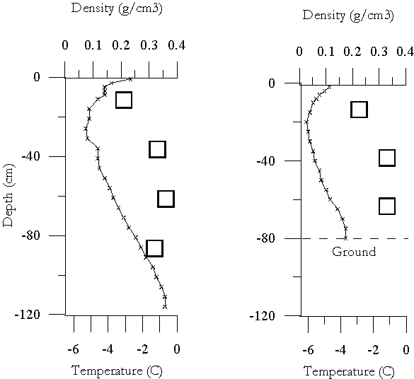
As can be seen in Figure 4 the measured temperature profile in the two snow pits (No 1 and 2) show the same pattern. There is a decrease in temperature from the surface and down to ~ 20 cm depth. Below ~ 20 cm of snow depth the temperature starts to increase towards the bottom. In both of the snow pits the minimum temperature is ~ -6° C but in snow pit No 1 the temperature
Fig 4.
Temperature and density profiles measured in snow pit No 1 and 2 in the Tarfala valley (Figure 1). The snow depth in pit No 1 was 120 cm and in No 2 80cm. It should be noted that in both of the two profiles the density sample closest to the ground was not sampled properly because of problems filling the density sampler completely, thus showing to low density values.at the snow - ground interface has risen to -0.7° C, compared to -3.7° C in the shallower snowpit (No 2). In the deeper snowpit (No 1) the snowpack is thick enough (120 cm) to dampen the influence of the negative energy balance during the winter and thus the ground has not been cooled. This is not the case in snowpit No 2 where the snowpack is shallower (80 cm) and the negative energy balance during the winter has been affecting the ground and cooling it to below 0° C and contributing to ground frost.
Snow pit density
The density measurements in the two snowpits (Figure 4) also show similar patterns with increasing density with depth. It should be noted that the density sample closes to the ground in both of the two snowpits contain errors because of problems filling the bottom cylinder completely. Thus the bottom density sample in both of the profiles show too low values.
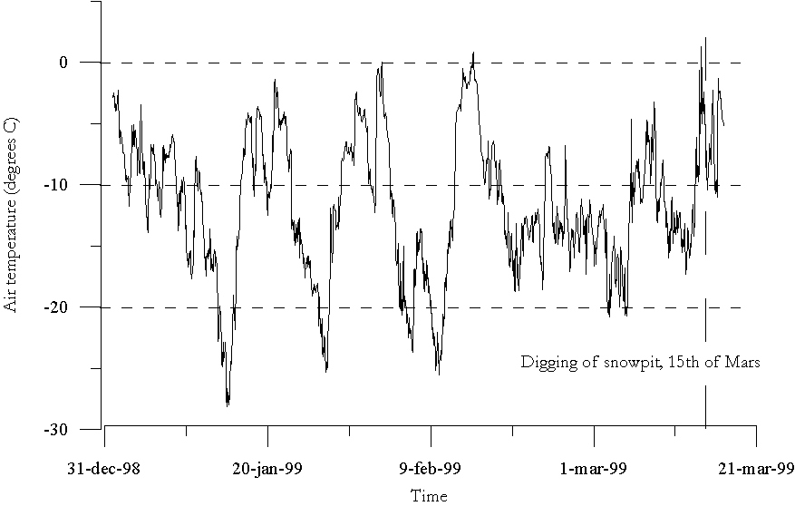
Figure. 5
Hourly average air temperature in the Tarfala valley between the 1st of January and the 16th of Mars 1999. The two snowpits were dug in the afternoon on the 15th of Mars.Snow pit stratigraphy
The air temperature record (Figure 5) from the Tarfala valley shows that between the 31st of December and 15th of March there were 4 periods when the air temperature dropped quite severely. Thus there were periods when a strong negative temperature gradient could have developed, potentially contributing to develop depth hoar in the snowpack. According to the field observations there was a very significant bottom layer of large ice crystals and at the very bottom depth hoar could be seen. In pit No 1 the coarse grained layer was ~ 85 cm thick and in pit No 2 ~ 60 cm thick.
The record of the air temperature in the valley also show that there has been three occasions since the 1st of January when the temperature has risen to ~ 0° C, indicating that there could be some ice lenses included in the snowpack due to melting and/or rain. The field observations reveal that there is one distinct ice layer in both of the two snow pits at 15 cm (No 1) and 20cm depth (No 2) which could have been formed during one of these occasions. The fact that the stratigraphy in the snowpack wasn’t very pronounced could be explained by the strong winds in the valley, redistributing the upper layers of the snowpack.
Snow depth measurements in the valley
The snow depth along the two transects varies between 50 and 300 cm and the average snow depth along the transects is about 150 cm. The small scale topography in the valley is characterised by large boulders and this influences the large changes in snow distribution pattern in the valley. At several places along the two transects the snow depth varies with 150-200 cm within only 20-30 m distance as can be seen in Figure 6 showing the snow depth along the south-north transect. It should be noted that since the valley is subjected to strong winds the redistribution of snow in the valley could occur frequently. Therefore the snow depth measurements made during this single occasion should be regarded with care.
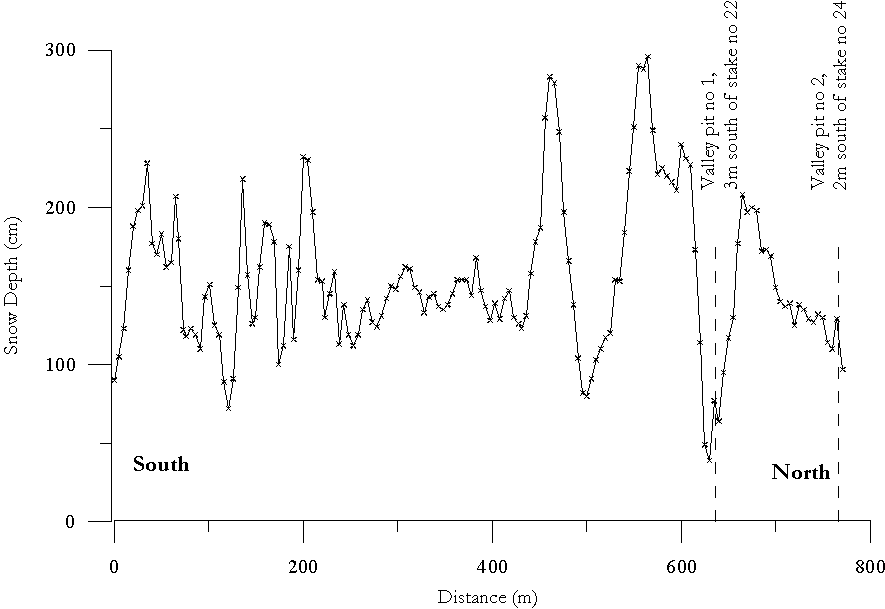
Figure 7.
Snow depth measurements along the south-north transect in the Trafala valley (Figure 1). The difference in altitude between south and north is approximately 25m.Conclusion
The cylinder used for measuring snow density had limitations. The bottom sample was difficult to sample properly, filling the cylinder to 100%. Thus the accuracy in these measurements were not high, within ~ 30 g dm-3. The equipment would probably have been even less accurate when used in bad weather, with strong winds.
The strength measurements used for different layers in the snowpack appeared very subjective even tough using the ISCI standard. The results from different peoples observations varied significantly and therefore there were differences in classification of strength of layers in the snowpack.
The measurements made during the field work seems to agree well with theory concerning stratigraphy, temperature and density profiles in the snow pits. The temperature profiles and density observations were according to earlier studies described in literature.
The variability in snow depth in the valley was very large and it would be interesting to make some further investigations concerning the variability in snow depth with time. Especially when considering the fact that the Tarfala valley very often experience strong winds and therefore a redistribution of the snowpack could occur often. Wind speeds up to 20 m s-1 is not rare in the valley. It would also be interesting to make a more thorough measurement of snow grain size in vertical profiles and to combine these measurements with wind observations in the valley.
References